For over a thousand years after the fall of the Roman Empire, many of the roads built by the Romans in Medieval England remained central to travel and trade across the country. A recent study reveals that these ancient routes played a crucial role well into the Middle Ages, offering a glimpse into how infrastructure from one empire influenced a much later era.
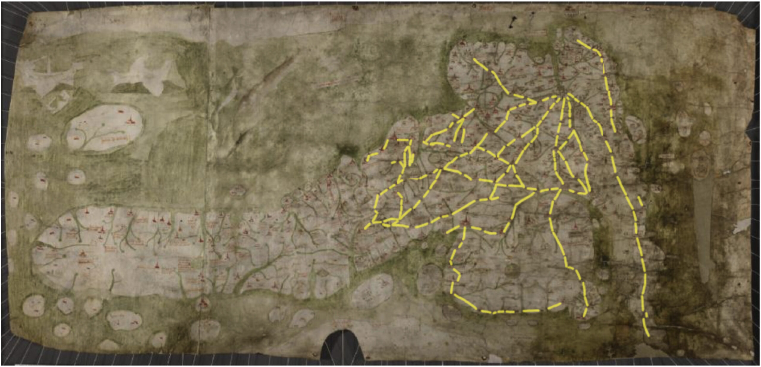
The findings, published in the Journal of Archaeological Science, focus on the Gough Map, a 15th-century map of Britain. This medieval map, drawn on animal skin, includes red lines linking towns and cities. While these lines were once thought to show distances, researchers now say they represent actual travel routes used in medieval times.
Roman Roads Still in Use During the 15th Century
Eijas Oksanen of the University of Helsinki and Stuart Brookes from the UCL Institute of Archaeology led the research. By using mapping tools and comparing data from ancient records, place names, and archaeological findings, they discovered that nearly one-third of the travel routes on the Gough Map follow original Roman roads. Another third were created during the medieval period, while the rest developed later.
Roman engineers built these roads between 43 and 410 A.D. to move armies and supplies across Britain efficiently. Although the Roman military left by the early 5th century, some roads—such as Watling Street and the Great North Road—remained in active use. These roads, built with solid foundations, continued to serve as important travel corridors well into the medieval era.
However, not every Roman road survived. Some were lost due to political shifts, including the break-up of England into small kingdoms, while others were forgotten as towns they once served disappeared or shifted locations. For instance, roads linked to the Roman town of Sorviodunum (now near Salisbury) became less important over time and eventually faded from use.
Roads Endured Where People Needed Them Most
The study also highlights how environmental and political factors affected the survival of these ancient routes. Roman roads built on dry, stable soil were more likely to remain usable, while those crossing wet or unstable ground often deteriorated. Areas with strong local governments managed to preserve roads more effectively, whereas regions facing conflict, such as forested border zones, saw roads fall into ruin.
In southern England, roads in the Thames Valley had mixed fates. Some segments endured in the chalk lowlands, but many were lost due to political instability and a growing preference for river transport. This area, once a frontier between rival kingdoms, saw less maintenance of its roadways during key periods of medieval history.
Another clue about the importance of these routes came from the study of thousands of coins discovered across the English countryside. Coins from the medieval period were often found near the routes shown on the Gough Map. According to the researchers, this pattern became more noticeable after the 11th century, when trade and movement increased.
The researchers concluded that the survival of Roman roads into the medieval period was not simply a matter of chance. Instead, it reflected a series of small, everyday decisions made by people over centuries—about where to travel, trade, and settle. These decisions gradually shaped the landscape of medieval England and kept ancient paths alive far longer than many had expected.